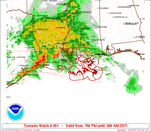
URGENT - IMMEDIATE BROADCAST REQUESTED Tornado Watch Number 251 NWS Storm Prediction Center Norman OK 755 PM CDT Thu May 16 2024
The NWS Storm Prediction Center has issued a
* Tornado Watch for portions of Southeast Louisiana Coastal Waters
* Effective this Thursday night and Friday morning from 755 PM until 300 AM CDT.
* Primary threats include... A couple tornadoes possible Scattered damaging winds and isolated significant gusts to 75 mph possible Isolated large hail events to 1.5 inches in diameter possible
SUMMARY...A broken squall line will move east into southeast Louisiana this evening and progress east across the Watch area tonight. In addition to the risk for a couple of tornadoes, severe gusts (60-75 mph) capable of wind damage may accompany the more intense portions of the squall line.
The tornado watch area is approximately along and 65 statute miles north and south of a line from 5 miles north of Lafayette LA to 35 miles east of Boothville LA. For a complete depiction of the watch see the associated watch outline update (WOUS64 KWNS WOU1).
PRECAUTIONARY/PREPAREDNESS ACTIONS...
REMEMBER...A Tornado Watch means conditions are favorable for tornadoes and severe thunderstorms in and close to the watch area. Persons in these areas should be on the lookout for threatening weather conditions and listen for later statements and possible warnings.
&&
OTHER WATCH INFORMATION...CONTINUE...WW 249...WW 250...
AVIATION...Tornadoes and a few severe thunderstorms with hail surface and aloft to 1.5 inches. Extreme turbulence and surface wind gusts to 65 knots. A few cumulonimbi with maximum tops to 500. Mean storm motion vector 27035.
BROWN CALLAHAN COKE COLEMAN CONCHO CROCKETT FISHER IRION KIMBLE MCCULLOCH MASON MENARD MITCHELL NOLAN REAGAN RUNNELS SAN SABA SCHLEICHER SCURRY STERLING SUTTON TAYLOR TOM GREEN
THE WATCH STATUS MESSAGE IS FOR GUIDANCE PURPOSES ONLY. PLEASE REFER TO WATCH COUNTY NOTIFICATION STATEMENTS FOR OFFICIAL INFORMATION ON COUNTIES...INDEPENDENT CITIES AND MARINE ZONES CLEARED FROM SEVERE THUNDERSTORM AND TORNADO WATCHES.
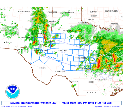
[html]MD 0809 CONCERNING SEVERE THUNDERSTORM WATCH 250... FOR THE PERMIAN BASIN INTO CENTRAL TEXAS
Mesoscale Discussion 0809 NWS Storm Prediction Center Norman OK 0754 PM CDT Thu May 16 2024
Areas affected...the Permian Basin into central Texas
Concerning...Severe Thunderstorm Watch 250...
Valid 170054Z - 170230Z
The severe weather threat for Severe Thunderstorm Watch 250 continues.
SUMMARY...The damaging wind and large hail threat will persist this evening.
DISCUSSION...A well formed line of storms which produced significant wind damage in parts of Midland has grown upscale as it continues to accelerate east. This will continue to pose a threat for 70 to 80 mph wind gusts as it moves east. Ahead of this line, a strong supercell which has a history of 2.75 to 3 inch hail continues to move east. This supercell and the squall line are both moving toward better instability. Additional cells are forming between the squall line and the mature supercell, but it is still uncertain if any additional well established supercells can develop. Given the more favorable downstream environment and the synoptic support from the upper-level wave, expect the threat from the squall line and any leading supercells to continue for at least a few more hours.
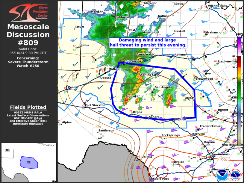
[html]MD 0808 CONCERNING TORNADO WATCH 249... FOR UPPER TX COAST...SOUTHERN LA
Mesoscale Discussion 0808 NWS Storm Prediction Center Norman OK 0749 PM CDT Thu May 16 2024
Areas affected...Upper TX Coast...Southern LA
Concerning...Tornado Watch 249...
Valid 170049Z - 170245Z
The severe weather threat for Tornado Watch 249 continues.
SUMMARY...Severe threat will spread across the remaining southeastern portions of ww249 this evening. Damaging winds, and perhaps a tornado or two, remain the primary risks.
DISCUSSION...Large MCS has matured over northern LA/upper TX Coast and is propagating downstream toward the lower MS Valley. Latest radar data suggests an MCV may be forming within the expansive precip shield over the lower Sabine River Valley. This feature is moving east and may contribute to the overall organization of the cluster as it spreads across southern LA. LLJ is forecast to strengthen across southern LA over the next few hours and latest VAD from LCH supports this with 0-3km SRH in excess of 550 m2/s2. Strong low-level warm advection favors a well-organized MCS advancing east and damaging winds remain the greatest risk along the surging bow-like structures. Additionally, some tornado risk continues with embedded supercells along the QLCS.
Last post by adminssd - SPC May 17, 2024 0100 UTC Day 1 Convective Outlook
[html]SPC 0100Z Day 1 Outlook
Day 1 Convective Outlook NWS Storm Prediction Center Norman OK 0746 PM CDT Thu May 16 2024
Valid 170100Z - 171200Z
...THERE IS A SLIGHT RISK OF SEVERE THUNDERSTORMS THIS EVENING INTO TONIGHT ACROSS PARTS OF THE TEXAS EDWARDS PLATEAU...THE UPPER TEXAS COAST AND SOUTHERN LOUISIANA...
...SUMMARY... An organized cluster of storms may pose a continuing risk for severe wind gusts across parts of southern Louisiana through late evening.
...01Z Update... A large, modestly organized cluster of storms is in the process of propagating east-southeastward across upper Texas coastal areas and southwestern Louisiana. Ahead of this activity, inland of the Louisiana coast, notable boundary-layer layer cooling has already occurred (4-8+ degrees the past 3 hours), beneath relatively warm layers evident in the lower/mid-troposphere in the 00Z soundings (e.g. Lake Charles). However, it is still possible that low-level moistening off the Gulf of Mexico, coincident with strengthening south to southwesterly flow (30-50+ kt) in the 850-700 layer, may contribute to a continuing severe wind risk with the convective cluster across at least southern portions of Louisiana through mid to late evening.
In the wake of the prominent lead convective cluster, outflow has contributed to substantial stabilization of the low-level environment across much of central Texas toward upper/middle Texas coastal areas and Deep South Texas. Models suggest little appreciable modification this evening, with further southward and southwestward progression of the outflow boundary into Deep South Texas and the Rio Grande Valley. As strong to severe convection now spreading across the Edwards Plateau vicinity encounters this environment during the next few hours, it seems likely to weaken.
Last post by adminssd - Caitlin Clark remains optimistic ahead of Fever home opener after lackluster WNBA debut
[html]Indiana Fever rookie Caitlin Clark is adjusting well to the pressure of the WNBA. She maintained a positive mindset ahead of Thursday's home opener despite an underwhelming pro debut.[/html]
Last post by adminssd - House Passes ‘TICKET Act,’ Disclosing Final Ticket Price To Purchasing Customers
[html]The House passed the Transparency in Charges for Key Events Ticketing Act (TICKET) on Wednesday in order to help consumers see up front just how much they will actually end up paying for a ticket, avoiding hidden surcharges.[/html]